
Biodiversity Conservation
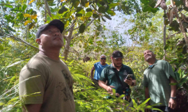
9 February, 2016, Nauru - A training on Geographic Information Systems (GIS) was successfully completed today for officers of the Nauru Fisheries and Marine Resources Authority and Department of Commerce Industry and Environment.
The training was run by Secretariat of the Pacific Regional Environment Programme (SPREP) and is a key activity of the Nauru GEFPAS Integrated Island Biodiversity (IIB) Project to provide basic GIS skills that would be useful to support planning and sustainable management of biodiversity resources.
 SPREP GIS Trainer Ryan Wright helping a Nauru Fisheries Officer with a GIS Query
"The GIS Training was a great success and was very well received as was evident through everyone's active participation. The training was simple and practical and met with everyone's expectations. A more advanced training for those who wish to further develop their GIS skills may be something to be considered for the future," said Mr Being Yeeting of the Nauru Fisheries and Marine Resources Authority.
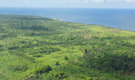
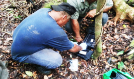
During the training, participants learnt how to use GIS software, specifically how to overlay infrastructure, fisheries, district boundaries, proposed marine managed area datasets onto a satellite image of Nauru. They also learnt how to map tabular data and record coordinates out in the field using a Global Positioning System (GPS) unit, uploading them to the GIS programme.
"Today's GIS capacity building exercise in free open-source, GIS software was a great success with Nauru Fisheries, members of the community, Environment and Quarantine departments all picking up spatial analysing skills incredibly quickly and applying them to Nauruan data layers. They were all great participants and I hope they continue to grow their skills in the spatial field" said Mr. Ryan Wright, the Spatial Planning Officer at SPREP.
Nauru community representatives participating in the training also had the opportunity for hands on learning, "GIS is a very important tool for identifying critical community areas for conservation, the training today will bridge the gap in capacity to map and illustrate these important areas for communities" said Mr. Tyrone Deiye, community representative from the Ijuw district.
To promote south-south learning and exchange, participants from the Cook Islands, Tuvalu and Tonga also took part in the training, "I found the training today very useful in that I learnt new techniques on mapping" said Ms. Moe Saitala, IIB project coordinator for Tuvalu.
The training was a collaborative partnership between the Secretariat of the Pacific Regional Environment Programme (SPREP), the Nauru Fisheries and Marine Resources Authority and the Department of Commerce Industry and Environment, Government of Nauru.
The training was run by Secretariat of the Pacific Regional Environment Programme (SPREP) and is a key activity of the Nauru GEFPAS Integrated Island Biodiversity (IIB) Project to provide basic GIS skills that would be useful to support planning and sustainable management of biodiversity resources.
During the training, participants learnt how to use GIS software, specifically how to overlay infrastructure, fisheries, district boundaries, proposed marine managed area datasets onto a satellite image of Nauru. They also learnt how to map tabular data and record coordinates out in the field using a Global Positioning System (GPS) unit, uploading them to the GIS programme.
"Today's GIS capacity building exercise in free open-source, GIS software was a great success with Nauru Fisheries, members of the community, Environment and Quarantine departments all picking up spatial analysing skills incredibly quickly and applying them to Nauruan data layers. They were all great participants and I hope they continue to grow their skills in the spatial field" said Mr. Ryan Wright, the Spatial Planning Officer at SPREP.
Nauru community representatives participating in the training also had the opportunity for hands on learning, "GIS is a very important tool for identifying critical community areas for conservation, the training today will bridge the gap in capacity to map and illustrate these important areas for communities" said Mr. Tyrone Deiye, community representative from the Ijuw district.
To promote south-south learning and exchange, participants from the Cook Islands, Tuvalu and Tonga also took part in the training, "I found the training today very useful in that I learnt new techniques on mapping" said Ms. Moe Saitala, IIB project coordinator for Tuvalu.
The training was a collaborative partnership between the Secretariat of the Pacific Regional Environment Programme (SPREP), the Nauru Fisheries and Marine Resources Authority and the Department of Commerce Industry and Environment, Government of Nauru.